- Home
- →
- University Archives
- →
- University Photo Collection
- →
- View Item
JavaScript is disabled for your browser. Some features of this site may not work without it.
| dc.date.accessioned | 2011-11-26T17:04:40Z | |
| dc.date.available | 2010-11-26T17:04:40Z | |
| dc.date.created | 1942 | |
| dc.date.issued | 1942 | |
| dc.identifier.other | 98.03.0051 | |
| dc.identifier.uri | http://library2.smu.ca/xmlui/handle/01/20283 | |
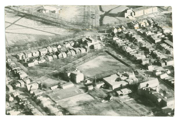
| dc.description | b&w photograph | |
| dc.description | Good. Remnants of tape along top edge. Scratch just left of centre. Tape on top two corners of reverse. Remnants of mat on reverse. | |
| dc.description | Aerial photograph of St. Mary's College campus at junction of Windsor and Quinpool streets, taking up centre section of lower half of photo, with various large buildings and substantial grounds. Robie St. runs diagonally from left centre to upper right corner, with both north and central Commons above it at top of photo. Cogswell St. runs to upper left corner. Bell Rd. runs to top centre of photo. Quinpool Rd. runs diagonally from bottom right corner to near-centre of photo, while Windsor St. runs diagonally almost to bottom left corner of photo. The unique layout of this 5-pronged intersection is unchanged to this day. | |
| dc.description | Written in pencil on reverse: '207.0'. Photo comes from Art Gallery. It appears the original photo it is based on is from the Nova Scotia Archives, which is the source of the date: https://novascotia.ca/archives/eastcoastport/archives.asp?ID=2 | |
| dc.description.provenance | Made available in DSpace on 2010-11-26T17:04:40Z (GMT). No. of bitstreams: 0 | en |
| dc.format.extent | 4.7 cm x 7.3 cm | |
| dc.relation.ispartofseries | Saint Mary's History Map -- Windsor Street | |
| dc.subject.other | Saint Mary's High School | |
| dc.subject.other | Campuses | |
| dc.subject.other | Windsor Street Campus | |
| dc.subject.other | North End | |
| dc.title | Aerial View of Saint Mary's College on Windsor Street, 1942 | |
| dc.type | Image |